Red flag warning issued for southern Willamette Valley July 8
3 min read
A red flag warning was issued Monday for Eugene-Springfield and the southern Willamette Valley, as the National Weather Service predicted afternoon winds of 10-15 mph with gusts up to 25 mph.
Due to the red flag warning and expected winds, the electric utilities have set their systems to “High Sensitivity,” which reminds us that power can be shut down for extended periods during weather events to prevent catastrophic wildfire.
The red flag warning is in effect from 1 p.m. to 7 p.m. Monday, July 8, 2024.
The red flag warning means a combination of weather conditions can contribute to extreme fire behavior, including rapid fire spread.
The weather is predicted to be hot and dry with low relative humidity and breezy northerly winds across the southern Willamette Valley on Monday.
In addition to the predicted winds, relative humidity is expected to drop as low as 15 percent.
Use extra caution with potential ignition sources, especially in grassy areas. Outdoor burning is not recommended.
The excessive heat warning continues through 10 p.m. Tuesday July 10. Dangerously hot conditions with temperatures between 100 and 105 degrees are expected, with warm overnight temperatures limiting recovery and exacerbating the risk of heat-related illness during this prolonged heat wave.
- Drink plenty of fluids, stay in an air-conditioned room, stay out of the sunshine, and check up on relatives and neighbors.
- Do not leave young children and pets in unattended vehicles. Car interiors will reach lethal temperatures in a matter of minutes.
- Take extra precautions when outside. Wear lightweight and loose fitting clothing. Try to limit strenuous activities to early morning or evening. Take action when you see symptoms of heat exhaustion and heat stroke.
- To reduce risk during outdoor work, the Occupational Safety and Health Administration recommends scheduling frequent rest breaks in shaded or air conditioned environments. Anyone overcome by heat should be moved to a cool and shaded location. Heat stroke is an emergency! Call 911.
- For sheltering information and other human services, see Lane County Cooling and Smoke Shelters or contact 211 by dialing 211 during business hours or visiting 211info.org.
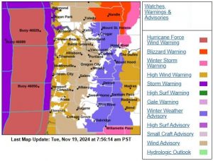
The red flag warning is issued for Oregon fire weather zone 685, which extends: north to include Corvallis, Lebanon, and Albany; south to include Creswell and Cottage Grove; and southeast to include Fall Creek, Dexter, and Lowell.
Sign up for Lane Alerts to be informed about changing conditions by local emergency managers.
UPDATE (July 8, 4:26 p.m.) from the Lane County COAD:
- St. Vincent de Paul will continue to operate the cooling center at the Lane County Fairgrounds 10 a.m. to 8 p.m. through Tuesday evening. Pets are welcome. They saw 40 people come through on Sunday.
- Springfield City Hall will continue to operate extended hours, noon to 8 p.m., through Tuesday.
- City of Eugene Library will continue to have extended services and the use of the Bascom/Tykeson room for cooling. Pets and food allowed.
- First Christian Church in Eugene will be offering a shade tent, and misting station on Tues/Thurs from 11 a.m. to 2 p.m. and a BBQ for folks who are unhoused on Friday from 5 p.m. to 8 p.m. in the North Courtyard.
- Due to the red flag warning and expected winds (10 – 15 mph with gusts up to 25 mph), the electric utilities have set their systems to High Sensitivity, meaning that there is a higher possibility that there will be power outages of an extended duration. People should prepare for that possibility.
- The most up-to-date information can continue to be found at: https://www.lanecounty.org/cooling
- Up-to-date information can also be found on social media at @lane_countyHHS on Instagram or Lane County Health & Human Services on Facebook.
- Lane County has produced an on-line Summer Survival Guide that can be found here: https://www.lanecounty.org/cms/One.aspx?portalId=3585881&pageId=20335473
The “most likely” temperatures have 85%-95% probability of happening; worst-case scenarios 5%-10% probability. Today’s numbers:
- Monday 7/8: most likely up to 103 and worst case 108 F
- Tuesday 7/9: most likely up to 101 and worst case 108 F
- Wednesday 7/10: most likely up to 93 and worst case 100 F
- Thursday 7/11: most likely up to 88 and worst case 95 F