Opinion: State map should show east wind fire risk
5 min read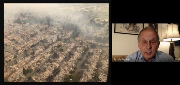
Randy Prince (Eugene Neighborhoods’ Preparedness Network): Hi, I’m Randy Prince. I’m representing the Eugene Neighborhoods’ Preparedness Network. We’re an organization working to help prepare residents—city residents of the city of Eugene and Springfield—for disasters, things that are beyond the normal capacity of emergency responders.
It’s wildfire season, and it so happens that on the agenda for us to act on as citizens is a wildfire hazard map being drawn up by the state of Oregon. This map has been in the works for a while, and this is the second time that a wildfire hazard map has been on the agenda.
[00:00:45] And that project is being coordinated under a charge from the legislature. Oregon State and other experts are looking at wildfire risks primarily in the wildland-urban interface (WUI). That’s the more rural areas that surround cities where houses have crept into there and it’s a difficult time with trees, sometimes too much vegetation and such. This is the main effort.
[00:01:13] Unfortunately, I think that we as city residents should speak up and call attention to something that is missing. And that is the perspective of what happens if a wildfire gets into the city. It can and it will. It has in California and it will and it has in Oregon. And it will. Certain types of winds, extreme wind conditions. In California, they’re known as the Santa Ana winds and the Diablo winds. In Oregon, it’s the east winds, can burn down cities.
[00:01:49] It doesn’t matter what the defensible space is. Santa Rosa, the Tubbs Fire, one of the most destructive in history: $1 billion damage, dozens of lives lost, closely-spaced houses. It’s a matter of spreading from one house to the next.
[00:02:04] If you look on the map that is to be issued by the state, you will see that most of the areas at risk from this particular type of fire that happens in the fall, the east wind fire, is in relatively low risk areas on the map. This doesn’t help us. That’s my opinion. We’re considered low risk. It’s the perspective of foresters and vegetation burning in a more normal dried-out, worsening climate conditions, but normal wind patterns and such that dictate this map.
This does not reflect the real risk to us as city residents.
[00:02:50] I’d like to encourage you to tell the state that they should be looking at the factors that endanger us in the city and that is wind, that are the east winds. Cliff Mass, a University of Washington climate scientist and his blog: Strong winds easterly from the east that’s because it’s high elevation in the east and the center part of the continent, in Colorado, the winds come from the west downslope onto the Great Plains and have caused significant damage there. We are at risk. All of the fires that have happened in California and the ones in Oregon that have been most destructive are a result of this type of fire.
[00:03:38] This catalogs the kind of losses that have been experienced. I think if you take a close look at the map that is being offered, they are underestimating the role of these winds that come in the fall, the ones that cause fires that can’t be controlled and can burn down homes that are not resilient, that are not prepared, irrespective of the climate conditions. We need, as city residents, to have some planning for that.
[00:04:06] One thing: These types of winds are less frequent. We have dozens of fires burning every summer in the Pacific Northwest. The east wind fires that have burned the city of Oakland, Santa Rosa, that Almeda Fire burned up Phoenix and Talent, are not common, but they are real. And they have happened for centuries and they’re in history.
[00:04:36] And these types of massive fires, the most famous is the Tillamook Fire. Then in 1933, the city of Bandon burned up. Again, east wind fires, less common. And those are the ones that we city residents have real reason to worry about. Tillamook Fire, Bandon Fire, they’re in history but they are forgotten in this map and they’re forgotten in the awareness of people. And it’s important that as climate changes it’s possibly more likely to affect us, not just once every 50 years, but maybe once every 20 years. And that’s important.
[00:05:12] And again, these types of fires can burn where there’s no forest. Here in the Front Range of the Colorado Rockies, fires swept down, a westerly wind because of the elevation difference, 1,000 houses burned, and that Marshall Fire is one that they are studying. What caused the homes to burn, in what was basically a grass fire? What can be done to protect houses? Will anybody work on implementing those changes? They will, if they’re aware of it. And the New York Times has featured the work of the Insurance Institute, the IDHS. They are testing in laboratories, burning down buildings, to see how city dwellings can resist the uncontrollable fires that occasionally with great impact, endanger us in the cities. We also need to know about how to evacuate quick enough.
[00:06:22] These fires spread driven by winds that might range from 40 to 60 to 100 miles an hour. Our emergency preparedness, our emergency response systems are not always prepared.
[00:06:35] If you notice people in Blue River and in the Almeda Fire, in Lahaina and all of these places, the alert system, the evacuation system was not up to the challenge and many buildings burned that might have been prepared by the kind of research and the changes to the building code in the city.
[00:06:56] What should you do when making your comments by Aug. 18, that’s Sunday, they are accepting public comments? Ask that we city residents be protected with information, that the risk to us be recognized. They’ll show you those maps. And believe me, they don’t correspond to where these east wind fires can occur and where cities might burn. I’m not going to go into the details. A lot of it is speculative, but we need to recognize this in some way.
[00:07:29] One way to recognize it was simply to say: ‘That part of the map is blank. We don’t know enough yet, but we’ll fill it in later.’ Don’t identify it as low-risk. That’s my message.
[00:07:40] I hope that you are able to express this point of view to the state in your comments on Sunday by Sunday, Aug. 18 to work for a better map that will drive the progress of toughening up building codes and improving our incident response, so that people can be evacuated when these fall season east wind fires occur here in the Pacific Northwest. Thank you.
Public comment can be sent by email to: hazardmap@odf.oregon.gov.