High wind advisory with gusts up to 45 mph in effect starting 4 p.m. Nov. 19
2 min read
from the National Weather Service Forecast Office, Portland and Sam Broadway of KEPW Newsday
An extremely powerful storm system will continue to bring heavy mountain snow, rain, and high winds to the Pacific Northwest and northern California through midweek.
The rapidly strengthening and extremely powerful low pressure system is forecast to pass roughly 300 miles west of the Olympic Peninsula overnight Nov. 19.
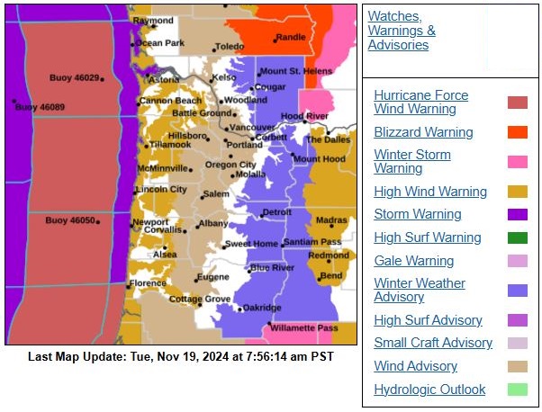
Damaging winds with gusts up to 70 mph are possible across northern California, as well as parts of Oregon and Washington, with the highest winds expected along the coast and high terrain.
These winds are likely to produce numerous power outages and tree damage in the most impacted regions. When combined with heavy snowfall at the higher elevations, blizzard conditions are in the forecast throughout the Washington Cascades.
As an associated frontal boundary slides southeastward and stalls near northern California on Wednesday, a deep and continuous plume of anomalous atmospheric moisture content will flow into the Redwood Coast of California and northern mountain ranges of the Golden State.
Heavy rain and rising snow levels will increase the threat of numerous floods and potential mudslides, exacerbated by the duration of heavy rainfall through the end of the week. In fact, a High Risk (level 4/4) of Excessive Rainfall across parts of northwest California on Thursday was issued to further highlight this flooding threat.
Residents and visitors throughout the Northwest are urged to have multiple ways to receive warnings, listen to advice from local officials, and avoid traveling through hazardous weather conditions if possible.
In the Eugene-Springfield area, a wind advisory is in effect from 4 p.m. Tuesday, Nov. 19 to 4 a.m. Wednesday, Nov. 20 with south winds 20 to 30 mph and gusts up to 45 mph here and throughout the Willamette, Lower Columbia, and Cowlitz watersheds.
Gusty winds will blow around unsecured objects. Tree limbs could be blown down and a few power outages may result.
Higher winds are predicted along the coast, with small craft advisories, storm warnings, and hazardous seas warnings. As of Nov. 19, hurricane-force winds are predicted along the entire Oregon coast.
Six to eight inches of rainfall could fall alone on Wednesday as a strong flux of moisture from the Pacific trains over the region due to a nearly stationary area of strong low pressure out in the Pacific.
Mountain ranges in the Northern Rockies, northern California, and the Cascades in Oregon and Washington could see feet of heavy, wet snow. This snow may be impactful for hazards. The winter storm severity index has some ranges in the major to extreme impacts, with power outages and downed trees some of the specific hazards.
Another notable threat with the system is the strong winds associated with a deepening area of low pressure. Many coastal regions are under a storm warning for wind gusts over 70 mph and possible coastal flooding hazards.
Use extra caution when driving, especially if operating a high profile vehicle. Secure outdoor objects such as garbage cans and other objects that can easily blow around.


