EWEB shares latest on Leaburg Canal seepage
9 min read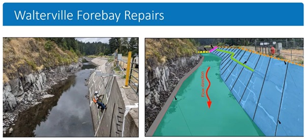
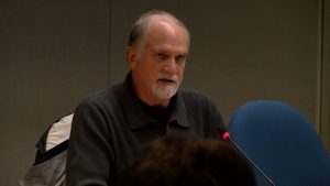
Presenter: A federal regulatory agency is following up, after asking EWEB to address seepage along the Leaburg Canal. Before commissioners Jan. 6, Generation Engineering Supervisor Mark Zinniker:
Mark Zinniker: Along the five-mile canal, we have a number of named and unnamed tributaries, some of which, like Johnson and Cogswell, are quite big. In an extreme wet weather event, they’re capable of putting more water into the canal than we would ever have during normal operations. And even a fairly normal wet weather event can fill the canal to high levels.
So although the canal may normally be running very low these days, when a storm refills it, all of our problematic seepage areas do come back to life.
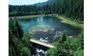
Cogswell Creek, normally essentially a dry creek bed—transformed into whitewater during a pretty normal wintertime storm. Normal conditions at Johnson Creek, a gentle flow through a meadow—and the overbank condition that happens each winter during a bigger storm event.
EWEB and our regulators recognized these risks during the first wet weather season after we went out of service and we quickly received letters from FERC Dam Safety, directing us to find ways to decrease water levels and provide additional low-flow outlet capacity.
We have just two low-level outlets for the canal. The largest outlet is near the upstream end of the canal. It’s at the wasteway gate. Unfortunately, that one’s located upstream of where most of the creeks—including the largest creeks—enter the canal.
And then we have a small, low-level outlet at the downstream end of the canal at the forebay. Though much smaller than the wasteway gate, it’s very important due to its downstream location.
The small 36-inch sluice gate was initially the only low-level outlet that we had. It had a capacity of less than 100 cfs (cubic feet per second). And we keep it open at all times.
When you drive on by the forebay on Highway 126, you will see whitewater flow from this small outlet passing through the chute under the highway and back to the river. The additional chutes—seven siphon spillway chutes—those require water to completely fill the forebay before they activate, which means that water also completely fills the canal. So not a good condition to be in when we’re worried about seepage and internal erosion.
Presenter: EWEB quickly acted to increase low-level outlet capacity by a factor of 10. Mark Zinniker:
Mark Zinniker: The removal of the turbine runner from Unit 1 at the Leaburg Power Plant—Jeremy (Somogye) led this project, which increased our low-level outlet capacity by a factor of 10, to 10,000 cfs.
We carefully monitored the low-level outlet during the 24-25 wet weather season, which led to the discovery of some structural problems with the trash rack needed to keep debris out of the system. Following authorization of emergency repairs in November, the repairs were performed in December and are nearly complete now.
Our next targets for risk reduction efforts are the two biggest creeks, Johnson and Cogswell. Our consultants at McMillen have worked hard in ‘25 to determine and design options we can implement most rapidly for these creeks, and we expect to be bringing those proposals to FERC Dam Safety in 1Q 2026.
In preparation we are currently doing subsurface explorations along the canal. FERC approved that drilling plan in September of this year of ‘25 and drilling started in November and we will continue into this new year.
So moving down to Walterville, a few updates there. We’re nearing completion of the forebay liner design, and expect to be submitting it to FERC in Q1 2026 with a hope to be able to construct in Q3.
We also recently submitted updated flood analyses to FERC, and we’ll be submitting updated seismic stability analyses later this month.
With these studies completed, we’re now in a good position to perform a strategic evaluation of the Walterville development to support decision-making on whether EWEB should position for relicensing at Walterville in 2040, or prepare for decommissioning there as well.
Presenter: Engineering Planner Jeremy Somogye:
Jeremy Somogye: The Leaburg Decommissioning Program is in motion, and some of the work we accomplished last year:
Concluded our baseline hydraulic and hydrologic models, which are analyses to better understand the impacts of water that flows into and out of the canal.
EWEB worked with the Lane County Public Works team to develop transportation alternatives and river crossing alternatives for the impacts of removing the Leaburg Dam, which does also have a river crossing on that dam.
This work was completed about a month ago, and we initially developed six alternatives, but we carried four through a full triple-bottom-line analysis where we evaluated the economic, the social, and the environmental tradeoffs of those four alternatives.
We plan to share this work and this analysis with the EWEB board in the coming month, and we plan to keep working with Lane County on what the next steps are with that.
It’s also important to note that we did provide updates and design review documents to ODOT during the analysis, as well as we also met with ODOT and Lane County this past September prior to concluding this study.
Presenter: Commissioner Sonya Carlson:
Sonya Carlson: If we knew that there was something coming down the pipeline and it just wasn’t there yet, is there, do staff have the ability to kind of override and open it and bring it on so that it, it releases some of the, you know, ‘Hey, let’s turn it on now to prevent it from getting full.’
Mark Zinniker: Yeah, and that’s how we will operate the available outlets is: We maximize the flow through them. And that 1,000 cfs that Jeremy was able to accomplish with the improvement by removing the runner, that does help us in the vast majority of storms. (Oh, okay.)
The problem is that we still have to convey all that water—that 1,000 cfs that’s going out the low-level outlet at the forebay—through three, four miles of canal. (Right) Just the depth of water to convey it through that canal is enough to activate those seepage areas. That’s why we really want to go upstream to the real source. Those big creeks get it out quicker.
Sonya Carlson: We were, can you dig in a little bit more? When we’re drilling into this, it seems counterintuitive to put another hole in something we’re worried about having holes in. We’re getting just information about how its structure is forming and what’s happening down below. Is that correct?
Jeremy Somogye: That’s a great question. And that drilling program plan that we provided to FERC in May of ’23, and it took quite a while–till September of ‘25–to actually get approval on that. One of the reasons it takes so long is for, you know, FERC and their engineers and their teams and their specialists to review the complexities of actually punching holes into a water-retaining structure.
So there’s a lot of guidelines and there’s a lot of guidance that that has to be followed because those plans together are very complex. And so there’s a lot of time to review that, ’cause those are very, big concerns that we have with creating new fracking or hydraulic pressures that can possibly create some challenges for us.
A lot of what we do is to try to help mitigate some of those challenges and some of the potential risk of subsurface drilling and backfilling those holes, or not drill.
We expect to finish Phase 1, which is the first 29 holes, by mid-February. And if all goes well, we’ll be back out and complete the remaining subsurface explorations this summer and fall.
Presenter: Commissioner John Barofsky:
John Barofsky: When we gave direction to move forward with stormwater conveyances as our priority strategy for moving forward with getting into compliance with FERC on this canal, the plan is we basically block the thing downstream of Cogswell, reverse the flow and take it out the wayscape.
At that time there was also talk about returning Cogswell and Johnson Creek directly to the mainstem. And when I made the vote to go forward with stormwater conveyance, I wanted that option still to be in the mix as far as looking at it financially, economically, and environmentally, and so I want to know at what point that that drops off.
Because for me, in the long run, if we do stormwater conveyance and run it out through the wastegate, we’re still on on the hook liabilitywise with FERC and with the community in perpetual for this canal.
If we can get these streams free, flowing back to the mainstem, that liability goes away. So that, to me, that’s part of the equation that goes in there. Are we still looking at that?
Mark Zinniker: We are looking at it from two perspectives: the near term because of the priority of addressing the risks that we’re carrying right now, and then the long term, the decommissioning, on a longer time scale.
Cogswell Creek, Johnson Creek— both of those, we’re developing alternatives that consider both continued use of the canal versus routing directly with no long-term continued use of the canal.
It does look like, in the short term, we’ve got constraints about what we can accomplish for near-term risk reduction. But the long term, we are very interested in understanding the potential for non-canal conveyance of these larger creeks, in particular back to the river. So those remain on the table. We do expect that study to wrap up in 2026 and we’ll be able to share results with you.
Presenter: EWEB Generation Manager Lisa Krentz:
Lisa Krentz: I think it was the board’s guidance and it’s also staff’s preference to return to pre-project conditions where feasible. So we certainly are exploring any and all options for that to be incorporated into our decommissioning planning.
Presenter: Commissioner John Brown:
John Brown: Have you done any exploration or inventory about the watershed at Cogswell and Johnson about the timber? I mean, what’s the age and maturity of the timber and is there any way to compensate timber landowners not to harvest for the next couple, three years?
Because once they harvest, they clearcut it, and then the water flows increase by 20 to 30%. And with the turbidity and everything, have you done any of that research to see about what’s the status and the age of that timber and whether or not we have an opportunity there to maybe slow down harvesting in that particular watershed?
Lisa Krentz: That’s a really interesting idea. We haven’t done any proactive communication with the landowners on the upper portions of Johnson and Cogswell Creek, but it’s a very interesting idea.
John Brown: Well, I’m just thinking if, you know, they go up there and timber prices are in the tank now, but they come back and they clearcut it. They clearcut 1,000 acres up there, that’s going to change your water flow significantly.
Presenter: Commissioner John Barofsky:
John Barofsky: Yeah. The last thing I would like to say is, thank you to the team here, and for the community that’s watching. This has been a long process that has been deliberative and very well thought out.
Recently in the local media, there was an op-ed that was put out there and it made it sound like we weren’t doing our due diligence. This presentation and all of the presentations that I’ve received and that we’ve received over the years has shown that we have done our due diligence and we are doing this in a thoughtful, meaningful, and responsible manner.
So I just wanted that to be put out there because there is talk in the community that we are not listening to the community and that we are not doing things in the correct way. And I believe we are. And I think that that message needs to be stated publicly that our team is doing a great job and that we’re doing things as a board and as an agency to respect all players in this arena. So thank you for your work.
Presenter: EWEB Generation Manager Lisa Krentz:
Lisa Krentz: Thank you. We appreciate that. And the credit really does go to the team, including Adam Spencer (who is sitting in the back of the room), who’s done tremendous work on translating complex information for the public.
Presenter: EWEB works to address short-term risk at the Leaburg Canal, while commissioners and staff hope Cogswell Creek and Johnson Creek will be once again able to flow into the mainstem of the McKenzie.