Emergency managers prepare for ‘islands’ created by damaged roads, bridges
8 min read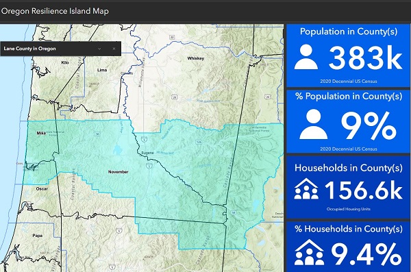
Lane County’s emergency manager spoke Sept. 12 about how planners are starting to look at areas that are cut off when residents can’t use roads and bridges. In disasters, these isolated areas can be mapped as ‘islands.’
Tiffany Brown (Lane County emergency manager, Sept. 12): We have applied for funding to create a mass care assessment for the entirety of Lane County that would incorporate the island mapping concept that we’re starting to see emerge around earthquake preparedness… As a county emergency manager of 15 years, this is the wave of the future. Applying the island mapping that we saw happen, even in the ice storm.
[00:00:38] John Q: To learn more about islands, we went back to a meeting of the Lane Regional Resiliency Collaborative, nearly a year ago. On Oct. 12, 2023:
[00:00:49] Greg Rikhoff (Lane County, Oct. 12, 2023): It’s increasingly clear that resilience, reducing risk, and recovering more quickly from large scale disasters requires cross-jurisdictional and cross-agency leadership, coordination and collaboration.
[00:01:03] This is a product of the University of Oregon and Lane County Policy Lab back in 2019, when there was a significant amount of coverage about a significant Cascadia event. We first worked to bring in Dr. Lucy Jones. We did this in cooperation with the Wayne Morse Center to help us understand what things we can be doing in advance of a very bad day and be ready for it in a way that really does help us be resilient.
[00:01:35] This Lane Regional Resiliency Collaborative is meant to allow Lane County to become better prepared and more cohesive as a community by leveraging federal and state dollars and to have the largest community impacts through collaboration amongst agencies that normally wouldn’t be sitting at the same table. So, this is all about linking, leveraging, and aligning.
[00:02:00] John Q: A champion of islanding:
[00:02:04] Matt Michel (Veneta city manager): I’m Matt Michel. This idea about islanding really hit home for me. Think about Cascadia hour plus 15: Where are your people? Can they get to your facility where you’ve got the capacity ready to go, where you’ve got the extra equipment, where they’ve got the training and know how to respond?
[00:02:21] But there’s a bridge out. Or something else has happened, transportation and access is cut off. In Veneta, what bridges are going to be out and what island is going to be happening? Veneta is going to be the beachhead for all those folks coming over from the coast, coming in (Highway) 126. They’re going to be exhausted, scared, wiped out from that event. They’re going to land in Veneta.
[00:02:45] And then it’s going to be an effort to push them forward into the valley to where they need to go. And that’s where ‘islanding’ is what we’re calling it, of: Where do these breaks happen? And what needs to be in these islands? And what communication between agencies needs to happen?
[00:03:03] For example, I started having conversations with Emerald PUD (People’s Utility District), knowing that several of my linemen lived on the other side of a bridge and would probably be able to report to Emerald’s headquarters at Seavey Loop, but not get all the way over to West Eugene.
[00:03:19] So I started a conversation: ‘Well, we should talk about who should deploy where, when Cascadia hits.’ And so you start planning, not just about training your people. We’re doing that now. That’s preparation, but we need to start thinking ahead and talking with our folks about: If you’re not able to get to headquarters, where’s your alternative report location?
[00:03:46] And two, talk with them about: Do you have your family situated that you’re able to leave them and report to duty? We can start doing some of that planning too. All this takes money, though. And we were already spending money to expand our facilities for that extra capacity, expending additional money to maybe to store additional supplies at substations out in the field.
[00:04:07] So you’re already sort of outspending today’s work. You’re spending into the recovery work. Now you need even more money, to spend it in resiliency work. That’s where the leveraging comes in.
[00:04:19] I see this all as a proof of concept of, if we can show that we’ve got these Conex boxes, we identify these islands, that gives us a roadmap to where do we go for grants to say: We have islands, we’ve identified them, we want to place equipment in these islands so that they can get stood up quicker while we’re waiting for access to appear.
[00:04:45] So it’s basically, we’re doing all of our work working in today, planning for that counterpunch when the event happens, but now we need to leverage each other’s vision for how do we help our people get to where they need to be and how do we make sure the equipment and facilities are there when they do get there.
[00:05:07] John Q: To speak about the islanding project, the resilience manager for Oregon Health Authority and the Oregon Department of Human Services:
[00:05:16] Mike Harryman: When I was the state resilience officer in Gov. Brown’s office, we used the Oregon Transportation Regional Resiliency Assessment, and we contracted with Haley and Aldrich. They developed in greater detail what the state would look like following a subduction zone earthquake and follow on tsunamis. They identified 31 zones in all.
[00:05:35] These are the 31 islands that Haley and Aldrich came up with. We named them using just alphabetical ‘Alpha Bravo Charlie’ stuff. Notice on the coastline there’s 21 regions. This is all public data and the map will zoom in on Lane County and it shows the county boundaries. And you’ll see there are more than one zone that connects to the county, from the zone Mike, Oscar, November, Whiskey, Zulu, Quebec even.
[00:06:07] You know, it’s been probably several years now where we wanted to really make sure whatever lands in Central Oregon from our federal partners and even some international folks to focus on two major areas to get open, and I call it ‘Plow on the road and plow on the river.’ So that we put a lot of pressure on the (US Army) Corps of Engineers and the Coast Guard to help plow the Columbia River up to Terminal 6 so that we can bring barges of food, water, and stuff like that into the greater Portland metropolitan area.
[00:06:35] And then we’re very dependent upon Highway 58 getting open from both ends, from the east side and the west side, so that we can then use Eugene as a central hub for basically the coast and southern Oregon until we get more road networks.
[00:06:49] And so on the state side, we’re going to look at our workforce. So I’ll give you an example. Department of Human Services has one of the largest state agencies. We have probably 14,000 employees and 187 buildings throughout the state.
[00:07:03] One of the things we want to do is, is work with our districts and identify where their staff work. We want to be sensitive not to use their home addresses, but if we just put all in Eugene, there’s 145 people work out of the Eugene office, even if they’re working remotely, it kind of gives us an idea of how to connect with them and communicate with them to find out, one, are they all right? Are they with their family? Can they come to work?
[00:07:26] And if we don’t hear from them, that just leads us down another path of figuring out how to track them down, because they might be a survivor inside a shelter, a survivor at an emergency assembly point that we are also developing with coastal communities.
[00:07:39] John Q: He demonstrated how to view your community using the interactive map.
[00:07:44] Mike Harryman: And I’m just going to come down here to Eugene and I’m going to pick this zone we call Zone November. And what Zone November tells us, we have 246,000 people living in there and 104,000 homes, and that just kind of gives you the idea of the zone itself and the populations you’re looking at for mass care operations.
[00:08:04] So that’s what we’ve been doing. And this is again, this has been churning away for the last—probably started in 2017 when we made our first request to Homeland Security to do this assessment. It just took them three years.
[00:08:19] But all the data that they came up with is also free data. It’s in the state data library. So those folks that have engineers or GIS folks that want to look at the data for how they looked at rivers, how they looked at bridges, and how they did landslide information, it’s free to play with.
[00:08:34] John Q: From the University of Oregon:
[00:08:37] Josh Bruce (University of Oregon): Our understanding of the state’s posture on developing islands is really thinking about where they’re going to land helicopters and bring in massive amounts of state asset, right, to address the 150,000+ people. And the number of households that are in the islands that the state’s identified, right? So that’s their perspective. How do they mobilize assets to serve really large blocs?
[00:09:03] What the county recognizes is that three islands is probably not going to be reality on the ground, right? We have 400+ water crossings in the county, be they bridges, culverts, other things.
[00:09:16] We have transportation corridors and other emergency assets that are also spread throughout the county. And so I think the concept was, while the state’s looking from a top-down perspective, what can the county do to pre-identify what we know will be smaller islands that exist within the large things that Mike just showed you.
[00:09:38] So we’ve taken an initial stab at identifying, like, where those tunnels are, water crossings and things like that, to come up with an initial sense of how the county might break itself out. We’ve identified six subislands within the county that are collections of upwards of 100 smaller islands.
[00:10:00] We’ve already opened up conversations about where assets might be located, similar things with the public workshops that are located throughout the county. And so really trying to think about not only what the state’s going to be able to provide, but what the locals will be able to bring together.
[00:10:16] The last thing I’ll say that informs this work is the county is in the process right now of identifying electric charging infrastructure on our primary transportation corridors.
[00:10:27] They’re trying to identify where we would charge electric vehicles or things like that. To inform that process, it would be good to know, where are the breaks at the local islands and how could those assets actually be leveraged in an emergency context, right? To provide emergency power or things like that.
[00:10:43] The same thing with some of those resilience hubs. If we know the locations of those local resilience hubs, that’s also information that the state can then use to understand, okay, where are we going to position our set assets so that communication can happen.
[00:10:58] John Q: The new state program Be 2 Weeks Ready and the county’s six resilience hubs are essential in preparing for the subduction zone earthquake, based on a model of areas that will be isolated and ‘islanded’ because of damaged roads and bridges.