You be the county commissioner: Yes or no on this riverfront subdivision?
6 min read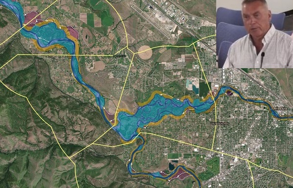
‘Yes’ or ‘No’ on a proposed new riverfront subdivision? On Sept. 12:
Tim Worley (Missoula County): For the record, Tim Worley with Planning Development and Sustainability, here to present Creighton Subdivision for eight residential lots and one utility lot. The project is located near the curve in 3rd Street and Clements in Target Range Orchard Homes, represented by Ken Jenkins of Montana Northwest.
[00:00:28] Just a little bit of history here. This subdivision went to Planning Board and the Board of County Commissioners all the way back in the summer of 2022. Our original recommendation was for subdivision denial. Time was needed to gather information about the specific erosion hazard on this property. You took public comment and you continued the hearing. Finally, in June, you reviewed a completed geotechnical analysis produced by ALLWEST (Testing and Engineering).
[00:00:54] Just some quick conclusions that came out of the ALLWEST study. Mature terrace materials characterize the subdivision property. These materials are less erodible than more recently deposited alluvial materials. Grantsdale soils on the property corroborate the mature terrace conclusion, and the mature terrace argues for a reduced erosion hazard area width, down to that 200 feet.
[00:01:21] Staff concluded that an independent verification of the geotech was appropriate and that is attached to our memo. His conclusion was essentially, ‘lacking riverbank erodibility and channel hydraulics information, the conservative yet prudent approach is to retain the 580-foot erosion hazard area.’
[00:01:44] So next steps from there: Staff at Montana Northwest Company agreed to return to the public hearing process, including both planning board and the county commissioners, that’s today obviously, with the geotechnical analysis, which can inform your decision about channel migration and its impact on the subdivision.
[00:02:05] Brian Throckmorton (406 Engineering): Brian Throckmorton with 406 Engineering, and then Ken (Jenkins, Montana Northwest) will hop up when I’m done.
[00:02:10] When you read the channel migration study itself, they break down the Bitterroot and the Clark Fork into what they consider reaches. So this is actually Reach 6, which is 4.9 miles long. So that’s a pretty big section of river to just have a generality placed on it. There’s a lot of site-specific items that happen in a five-mile stretch of river and actually 10 miles because you have both sides of the river that you’re putting 580-foot setback on.
[00:02:41] So the study does realize this, because this is a big thing. On page six it says the CMZ mapping developed in this study was developed without any explicit intent of either providing regulatory boundaries or overriding site-specific assessments. Any future uses of the maps as a regulatory tool should be careful to review the mapping criteria to ensure that the approach is used appropriate for that application.
[00:03:07] So, in essence, they know we recognize site-specific is more important than these big reach areas. It’s not used as regulation because it there’s too broad of a swath that you paint. It’s more for informational purposes only…
[00:03:25] If we needed to have a bigger setback of 250 feet, maybe have some buffer when we rearrange things, we could definitely put a ‘no-build’ an extra 50 feet if that makes anybody feel better.
[00:03:36] John Q: With the site-specific study:
[00:03:39] James Thomas: My name is James Thomas, and I’m the CEO and principal geotechnical engineer over at ALLWEST. I don’t think the nature of the deposits in the area of the evaluation are much in question at this point, but I wanted to get some slides in front of you that it does benefit you to get some eyeballs on the type of geology we’re dealing with at the site.
[00:04:02] These are the dense older terrace gravels that are pretty predominant through some of the areas of Missoula. We also did nuclear densometer testing of the in situ soil in the test beds, indicating in situ compaction of around 80 to 85, which for newer deposits, you never really get that high.
[00:04:21] And some of the soils exhibited localized caliche deposits or cementing and the sidewalls pretty much held a vertical wall, which indicates the dense nature of the material. And the USDA NRCS mapping was already corroborating the nature of the predominant soils below this site.
[00:04:41] Ken Jenkins (Montana Northwest Company): For the record, Ken Jenkins with Montana Northwest Company. I want to just talk a little bit about the process here…
[00:04:51] This process is required to be based on findings of fact, not recommendations and opinions like the whole process has been up till this point.
[00:05:01] Some feedback about the type of agency comments I’m talking about. This is recent from the Health Department:
[00:05:09] ‘If a positive element could be found in the previous plans, the homes would likely have been lost to river migration or flooding before the sanitary facilities,’ meaning there would hopefully not be families living in viable homes without a way to access water or properly dispose of wastewater.
[00:05:30] In that same letter of comment: ‘When we think about areas that are preferable for development with onsite water and wastewater facilities, this is not one of them. We had several concerns with the project, including high groundwater and significant portions in the channel migration zone and or floodplain.’
[00:05:51] So, these are the comments that the Planning Office has to build their recommendations on.
[00:05:58] When we’re engineering and designing subdivisions, there are always things that we have to look at and mitigate and there’s a black and white line. You’re either in or you’re out.
[00:06:11] Our clients paid ALLWEST to do a lot of work. They found the type of terraced soil that does not erode as fast. The county hired Tetra Tech to take a look at that work. They concurred with the soil type, but Tetra Tech then goes on to sort of speculate that ‘the prudent thing to do,’ I think, is how they worded it, would be to stick with the 565-foot (setback).
[00:06:39] The prudent thing to do might be to never approve a subdivision in the Missoula Valley again, because what about the next ice age? What about the next Glacial Lake Missoula? I mean, we cannot design subdivisions to comply forever in geologic time. We cannot speculate forever in geological time as to what the river might do.
[00:07:04] There’s already a city here. That study was done as if there were no houses, no subdivisions that are already in this thing, and that intervention by man would never take place… This is America. We don’t let subdivisions wash down rivers.
[00:07:22] So, I would just like to say that I think the review process has been a little bit negative in the comments that the Planning Office has to use to make their recommendation. That’s fine. I mean, there’s no rules against that, but I’m asking for a decision that’s based in fact, and we can only deal in designing a subdivision with what the facts are. Not speculation. Not what’s prudent. We have to go with the answers we get.
[00:07:58] We have followed the process that the channel migration study called for. We have studied the floodplain. We have measured the groundwater. We have done all of the things we’re supposed to do. And the answers are good. We can’t speculate outside of what we can actually measure today.
[00:08:20] The other thing I’d say, personally, I don’t think it’s ever going to be a problem. I grew up in this neighborhood, that little slough that’s along all of those lots. I used to go duck hunting and walk down through their fishing and that hasn’t changed at all. Not in my lifetime, not since I was a little kid. Looks the same now as it did then.
[00:08:39] John Q: Developer address the river channel migration study, and offer an extra 50 feet of ‘no-build’ zone. A decision on a riverfront subdivision in Missoula County could come in late October.