Thunderstorms, winds, hail predicted March 26
3 min read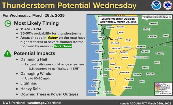
from the National Weather Service, Portland, ODOT, and staff reports
The stage is set for a rare and unusual weather event Wednesday, as the March 26 forecast calls for weather more typical of the Great Plains than the Upper Willamette.
The area is expected to see severe thunderstorms, high winds with gusts up to 60 miles per hour, hail up to two inches in diameter, and conditions that could create supercells, the type of thunderstorm with a rotating updraft that can produce tornadoes.
Wednesday is predicted to start warm, then become active during the afternoon with showers and possibly severe thunderstorms during the afternoon and evening hours. There is also the potential for strong damaging winds within thunderstorms, when the core of the thunderstorm collapses.
The National Weather Service bumped the area’s risk level Tuesday afternoon from marginal to slight, the first time this risk level has been issued in March west of the Rockies (according to records dating back to 2002).
High winds can often lead to downed trees, branches, and power lines. Review or follow EWEB power outages online, call EWEB at 1-844-484-2300, or text OUT to TXEWEB (893932). You must complete all prompts to record your outage.
Eugene residents can report flooding and tree hazards in the public right of way by calling 541-682-4800 between 9 a.m. and 4 p.m. Monday through Friday. During other times, call the police non-emergency line at 541-682-5111.
With many travelers on the road for spring break, the thunderstorms, heavy rain, and high winds could disrupt travel plans. Be prepared for sudden weather changes and take necessary precautions to stay safe.
Key hazards during storms
- Thunderstorms: Lightning, gusty winds, heavy rain and hail could create hazardous conditions for driving, biking and walking. Power outages and debris on roads are possible.
- High Winds: High winds may cause trees, limbs or powerlines to fall, potentially blocking roads and paths.
- Flooding: Heavy rain may lead to localized flooding, particularly on low-lying roads, bridges and areas near rivers.
- Heavy rain could also cause slides, blocking roads with debris.
- Reduced Visibility: Heavy rain and storm conditions may significantly reduce visibility, making travel more challenging.
Travel Safety Tips
On the road
- Slow down and drive with caution, particularly on wet roads.
- Be sure to turn on your headlights to improve your visibility and help others see you.
- Never drive through standing water, as it can be deeper than it appears and may hide hazards or cause your vehicle to stall.
- Keep a safe distance from other vehicles, especially when visibility is poor.
- Watch out for people walking and biking as they are less visible in bad weather.
Public transit
- Expect possible delays or service interruptions due to weather conditions, particularly in flood-prone areas.
- Allow extra time for your journey and check with transit agencies or rail providers for updates.
Biking and walking
- Avoid biking or walking in stormy conditions, especially in areas prone to flooding, as heavy rain and strong winds can pose serious hazards.
- If you must travel during the storm, stay vigilant and wear high visibility clothing.
Prepare for the unexpected
- Keep an emergency kit in your vehicle, including water, snacks, a flashlight and a fully charged phone.
- Ensure your vehicle is well-maintained and equipped for rain or wet conditions, including working wipers and good tires.
Stay updated on current weather conditions and to check road conditions and closures at TripCheck.com or by calling 511 for real-time updates.
Stay safe, stay informed and adjust your travel plans accordingly.