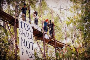
McKenzie ‘heroes’ help prepare for our second winter since the fire
5 min read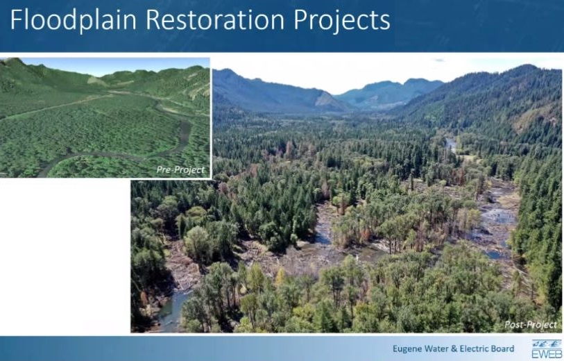
Restoration work in the McKenzie includes letting the river move more freely throughout the floodplain.
The EWEB board heard the latest on McKenzie River recovery this month.
[00:00:04] Karl Morgenstern: It is fitting on this one-year anniversary that we’re talking about our recovery and restoration efforts in the McKenzie to protect and restore our sole source of drinking water.
My name is Karl Morgenstern, watershed restoration program manager and leading the recovery effort as part of the task force. So it’s a multi-agency organization, not just EWEB. We have Lane County, Forest Service, Bureau of Land Management, a host of organizations and agencies working under these teams together.
I particularly wanted to pay special recognition to the Core Pure Water Partners that have really done the heavy lifting and frankly worked their butts off over this last year to get some great work done on the ground. And that is the McKenzie Watershed Council, Upper Willamette Soil and Water Conservation District and the McKenzie River Trust. They have been essentially the heroes of this effort in my mind.
As you recall, we had toxic ash debris, houses burned along the river that were ready to just dump stuff into the river with the coming rains. And so there was very much a race against rain to make some stuff happen on the ground. And we did, I think, a pretty admirable job of trying to stabilize at least the high priority areas.
One of the other things to keep in mind as we do this work is, it is on private property. And so we need to have the property owners’ access agreement, we need their support. And so one of the things that the Pure Water Partners Program provided us was that we already had 90 landowners in the pipeline of that program when the fire occurred. So it allowed us to work on those landowners’ properties that we already had access under the old Pure Water Partners Program quickly. A lot of work was done in a quick amount of time.
This work is really transitioning to doing more of what needs to be done on the ground to make us in a better position to restore the watershed. And that is continuing to take care of the plants we put in the ground, those 90 acres that were planted over the winter to make sure as many of those survive in the drought. We had 210,000 plants that we put in the ground, native plants, and we now have an order that is over 500,000 plants that we’re going to put in the ground this next winter.
Thank you for supporting
local civic journalism
As you all know, the lack of storms really was good for water quality. It’s bad for the drought we’re in, but we do not expect to dodge that bullet again this winter. Our network of water quality stations helps inform us real time and when things are coming unraveled that helps us respond as well as help our treatment operators plan for it. And so we really want to maintain monitoring of these so that if we are starting to see some of those compounds show up in the river, we want to know about it.
The resiliency work is a little bit more complex. One is these floodway acquisitions that we’re doing with the McKenzie River Trust to basically help landowners that really don’t want to rebuild, want to move on, but see an opportunity to give towards conservation, to be able to acquire those floodway properties, remove that infrastructure of the burned home, the septic systems and driveways, and then restore that area.
And then the other two areas are really into restoring large scale floodplains, and then in the tributary systems themselves, being able to set a large wood placement, that acts as what we’re calling “catcher mitts” to sediments and trying to slow down flows and treat things that are coming at us.
In the South Fork McKenzie, what the work does is essentially divert the river while we’re doing work in the floodplain. And we take the berms and stuff, the materials that keeping the river incised, and then we fill in the incised channel, then re-introduce the river back onto this floodplain, and let it pick where it wants to go. You see a lot of large wood there, that wood because of velocities are knocked down so much. There was a lot of concern about high velocity flows sending that wood downstream. And we have not seen that happen, even up to 5,000 CFS. So the wood is fairly stable and it’s designed to maintain this stability over time. But as you can see, it spreads out flow across the landscape, slows it down, drops out sediment and provides excellent habitat for fish and avian and amphibian species.
The floodplain restoration projects—Finn Rock Reach, the Delta Campground area, and Quartz Creek. And so if we are successful beyond all belief, over 70% of the burned area would be pre-treated before hitting the river.
So finally, the ‘Strategic Actions’ is really looking at that intersection between some of the work we’re doing in the watershed restoration and the opportunity to provide carbon sequestration benefits. And so we’re working with the University of Oregon on a lot of the research that is building the knowledge that will help influence future project design. They’re focused on these depositional environments that we’re creating from these floodplain areas to where we are able to sequester carbon in a way that secures it from future fires, for example.
A lot of the research being done is on this High Banks Road property, someday we’ll be able to bring you out there and you can see. And then U of O is doing some baseline carbon measurements on the floodplain project areas before we actually do projects and we’ll measure post project and compare that to control areas, to show the benefits of those projects are carbon sequestration.
[00:05:10] Commissioner Mindy Schlossberg: This is Commissioner Schlossberg. What is smart rebuild?
[00:05:13] Karl Morgenstern: Excellent question. We have a suite of incentives that we are rolling out for landowners who are looking to rebuild. A few of those are basically helping them to make it essentially cost neutral for them to move their house footprint away from the river out of the flood plain and out of the riparian area. And so those the grants that we have available for that allow them to move the house and then adjust the piping from their well and their septic system, as they need to accommodate that new footprint. And then we also have incentives around the septic systems to upgrade and septic systems and make them better. And I think I forgot to mention on the last one, the septic piece, the legislature did provide us 1.5 million for septic upgrades and repairs replacements.
[00:06:00] Commissioner Mindy Schlossberg: Commissioner McRae.
[00:06:01] Commissioner Matt McRae: As you know, landslide risk and erosion risk actually increases over the first several years, we would expect to see peak landslide risk in that watershed in three to five years out from this fire. The worst is definitely not behind us in terms of water quality impacts. And so I encourage us to go full force, as heavy as we can to try and mitigate water quality impacts, erosion potential as much as possible.