Hurricane Ian shows need for early warning systems
3 min read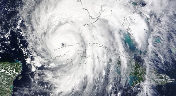
from UN News
Hurricane Ian caused devastation across western Cuba and increased its strength and size as it made landfall mid-afternoon local time on Wednesday, in the United States; meanwhile Typhoon Noru underwent an “explosive” intensification before it hit the Philippines, the UN Meteorological agency, WMO, has said.
The two tropical cyclones came quick on the heels of Hurricane Fiona, which caused deadly flooding in the Caribbean and was the strongest storm on record to hit Canada. Typhoon Nanmadol prompted the evacuation of nine million people in Japan.
The importance of early warnings
WMO underscored that accurate early warnings and coordinated early action are proving key to limiting casualties during extreme weather events such as Hurricane Ian, Fiona and Typhoon Noru.
“It is more important than ever that we scale up action on early warning systems to build resilience to current and future climate risks in vulnerable communities,” said WMO Secretary-General Prof. Petteri Taalas.
Fingerprints of climate change
The World Meteorological Organization has reminded that climate change is expected to increase the proportion of major tropical cyclones worldwide, and to increase the heavy rainfall associated with these events.
Meanwhile, sea level rise and coastal development are also worsening the impact of coastal flooding.
“The human and socio-economic impacts of these cyclones will be felt for years,” warned Cyrille Honoré, WMO Director of Disaster Risk Reduction and Public Services branch.
Hurricane Ian
Hurricane Ian slammed into Cuba on 27 September as a Category 3 storm, with sustained winds of 205km/h and even stronger gusts leading to flash flooding and mudslides.
It is estimated that more than three million people have been affected, the UN Resident Coordinator’s Office informed.
According to WMO, Cuban President Miguel Díaz Canel said that the damage caused by Ian will likely be significant, though only preliminary assessments have been carried out.
There were no immediate reports of casualties. But there was severe damage to infrastructure, housing, agriculture, and telecommunications, with power reportedly lost to the entire country. Pinar del Río, the hardest hit province, is home to 75 per cent of the country’s tobacco production – a key export for Cuba – and about 40 per cent of the nation’s bean production.
Florida on high alert
Ian is intensifying rapidly and is now a very strong category 4 hurricane (maximum sustained winds near 155 mph (250 km/h) with higher gusts). It is expected to maintain this intensity.
Ian is the first hurricane to make landfall in mainland United States this season.
The US national weather service warned of catastrophic wind damage near the core of Ian when it moves onshore and of life-threatening storm surge and catastrophic flooding.
The combination of storm surge and the tide will cause normally dry areas near the coast to be flooded by rising waters moving inland from the shoreline, according to expert forecasts. The water could reach up to 12 to 16 feet (3.5 to 4.8 meters) in the worst affected areas.
Heavy rainfall will spread across central and northern Florida through Thursday as it is forecasted to slow its forward motion. Ian is forecast to reach portions of the US Southeast later this week and this weekend (1-2 October).
Catastrophic flooding is expected across portions of central Florida with considerable flooding in, northern Florida, south-eastern Georgia and coastal South Carolina.
“Ian poses an exceptional threat because of its size, its strength and its landfall in a heavily populated, low-lying area”, WMO has warned.
Typhoon Noru
Meanwhile, in the eastern hemisphere, Typhoon Noru, known in the Philippines as Karding, hit the northeastern part of the Philippines on 25 September as a “super typhoon” with sustained winds of 195 km/h (121 mph) before tracking across the main island of Luzon on 25 September.
More than two million people live in the worst affected areas, according to a disaster analysis, and nearly 430,000 people were directly impacted. Despite the relatively short space of time for mobilization, thousands of people were successfully evacuated, limiting loss of life.
From 26-27 September, typhoon Noru made its way towards Viet Nam, and intensified once again.