Opinion: Use watershed names to identify Lane County commissioner districts
6 min read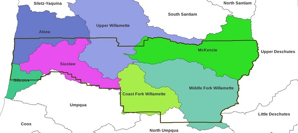
Thank you, Chair, Commissioners, staff, and Charter Review Committee members. For the record, John Quetzalcoatl Murray, Executive Director of the Corporation for Public Community Newspapers. We’re a local news nonprofit here in the Upper Willamette watershed part of Lane County.
[00:00:17] We support local news, an essential institution for democracy in so many ways. It’s part of our larger mission, sustaining democracy and self-governance. That’s also our goal in speaking today about the titles and descriptions of commissioner districts.
[00:00:37] We ask that you adopt an idea from John Wesley Powell. He mapped the Grand Canyon. He was the second director of the U.S. Geological Survey. He recognized the importance of water in the West, and he recommended one small adjustment to our American institutions.
[00:00:55] In 1889, at Montana’s Constitutional Convention, he proposed that administrative districts be based on watersheds.
[00:01:06] ‘I want to present to you what I believe to be ultimately the political system which you have got to adopt in this country and which the United States will be compelled sooner or later ultimately to recognize,’ Powell said. ‘I believe that the primary unit of organization should be…the drainage basin, which would practically have a county organization.’
[00:01:35] Montana did not adopt Powell’s idea but it has stood the test of time and now its time has come. We are facing megawildfire, megadrought, megaconflict over water resources. And our institutions for managing water resources are faltering.
We encourage you to adopt titles and descriptions for Lane County commissioner districts that list the names of the watersheds within those districts.
[00:02:02] Such a charter amendment will promote greater watershed awareness, a holistic approach to soil and water quality, air quality, habitat improvement, fish and wildlife, and public health. It will better position our descendants to respond to disruptive climate change.
[00:02:22] We’ve also submitted several maps showing how Lane County might also start discussions with our neighbors to snap Lane County to watershed boundaries. This is already done on the east and mostly done on the south.
[00:02:35] By aligning our administrative districts, as John Wesley Powell suggested, to increase awareness of our most precious natural resource, and by preserving affordable access to clean and healthy water for all, we can help preserve democracy in America.
The next public hearing is scheduled for Tuesday, July 9, 2024. Send your thoughts on using watersheds as commissioner district titles and descriptions to publiccomment@lanecountyor.gov with the subject: “CHARTER REVIEW PUBLIC COMMENT FOR MEETING DATE 7/9/2024.”
The written statement for the June 26, 2024 public hearing on Lane County charter review.
Chair, vice chair, commissioners, county administrator, Charter Review Committee members: For the record, John Quetzalcoatl Murray, executive director for the Corporation for Public Community Newspapers, a local news nonprofit here in the Upper Willamette watershed part of Lane County.
We are facing an unprecedented collapse of local news. Local news is such an important institution for democracy in so many ways. It is usually the sole source of information about local government, but it also reinforces our education system by offering ongoing civics and reading lessons. Headlines in big text are short and accessible to young readers. Editors can model correct spelling and grammar. Local news also creates jobs, and local ownership keeps that revenue circulating within the community.
We need more local news, more local news consumers, and more local journalists. Our nonprofit 501(c)(3) supports local news with several special projects:
- We are partnering with KEPW 97.3 to provide a free news service through our award-winning website, producing stories about boards and commissions, nonprofits and neighborhoods, preparedness and public comment.
- We have a local government document repository at Google Journalist Studio.
- We share our stories freely under our Creative Commons license, so other individuals or newsgathering organizations can take what they want to produce their own stories.
- We are training, partnering with, and publishing the work of local community journalists.
- We support all local news organizations, nonprofit and commercial. Our website shares links to the “Donate” pages of the Highway 58 Herald, The Chronicle, Eugene Weekly, KLCC, KEPW, Lookout Eugene-Springfield, and many others.
All of these projects support our larger mission: sustaining democracy and self-governance.
That is also our goal in speaking today about the titles and descriptions of commissioner districts: We ask you to adopt an idea to sustain our shared civic life.
This idea comes from John Wesley Powell, the second director of the U.S. Geological Survey, based on his understanding of the arid lands of western North America.
Powell recognized that limited water resources in the West would require one small adjustment to our American institutions. And so in 1889, he proposed to the original Montana state constitutional convention that the state’s counties be defined based on watershed boundaries.
“I want to present to you what I believe to be ultimately the political system which you have got to adopt in this country, and which the United States will be compelled sooner or later ultimately to recognize,” Powell told the Montanans. “I believe that the primary unit of organization…should be the drainage basin which would practically have a county organization.”
Powell gave much the same “watershed democracy” message to North Dakota. By snapping county boundaries to watersheds, residents would be better able to collectively manage their natural resources.
Montana and North Dakota did not adopt Powell’s ideas. Instead they followed the usual practice of the day, drawing county maps with mostly straight lines.
But Powell’s prescient ideas stand the test of time. They are worth reconsidering today, as human use of fire and our ingenuity in finding new fuels to burn have ushered in a new era of warming on our planet, what Stephen Pyne is calling the Pyrocene Age. We are already seeing more wildfire, drought, and conflict over water resources—just as our institutions for managing water resources are faltering.
We encourage you to take the first small step towards supporting John Wesley Powell’s notion of watershed democracy: We encourage you to adopt titles and descriptions for Lane County commissioner districts that list the names of the watersheds within those districts. Using watershed names for our political identities will foster greater awareness and develop our collective watershed consciousness.
To prepare for the next 10-year charter review, we can also start preparing today to align Lane County’s boundaries with watershed boundaries. We’ve also submitted several maps showing how Lane County might also start discussions with our neighbors, to snap Lane County to watershed boundaries. This is already done on the east and mostly done on the south.
Naming the commissioner districts by watersheds, then aligning administrative boundaries with watersheds, will promote a holistic approach to soil and water quality, air quality, habitat improvement, fish and wildlife and public health. It will better position our descendants to preserve and improve watershed health in response to disruptive climate change.
By preserving affordable access to clean and healthy water for all, we can help preserve democracy in America.
The next public hearing is scheduled for Tuesday, July 9, 2024. Send your thoughts on using watersheds as commissioner district titles and descriptions to publiccomment@lanecountyor.gov with the subject: “CHARTER REVIEW PUBLIC COMMENT FOR MEETING DATE 7/9/2024.”
Image: The following HU8 watersheds defined by the U.S. Geological Survey’s Watershed Boundary Dataset are present within Lane County: the McKenzie, Upper Willamette, Middle Fork Willamette, Coast Fork Willamette, Siuslaw, Alsea, and Siltcoos. Portions of the Umpqua and North Umpqua watersheds can be transferred between Lane and Douglas County to align the south Lane border with these watershed boundaries.