‘Ready Eugene’ helps neighbors prepare for flooding
11 min read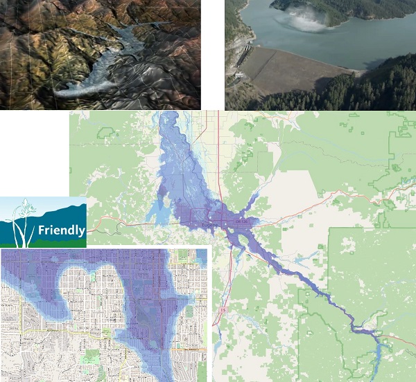
Preparedness volunteers from Eugene neighborhoods take a look at flooding scenarios. Launching the discussion Oct. 20 with the Friendly Area Neighbors, Craig Cherry.
[00:00:09] Craig Cherry (Ready Friendly): This is our first virtual evacuation exercise, prepared and hosted by volunteers from Ready Eugene and Ready Friendly.
[00:00:17] Our purpose tonight, really, is to educate ourselves about readiness in general a little more. And as an example of a potential hazard, we’re going to be talking about the dam failure scenario. That’s just one of many things that might happen, and that’s not a particularly likely thing to happen, but it does get people thinking a little bit—different possibilities compared to the trees burning up the hill.
[00:00:41] So just to stay flexible on that. We’re going to be reviewing the Lane County Emergency Alert notification system and the evacuation zones, and try to help people be sure they know how to sign up for those things. And also talk some about how to notify neighbors of an emergency, and help neighbors who might have special needs.
[00:01:02] And that really ties into the Map Your Neighborhood / Meet Your Neighbor program of being aware of, if there are some folks that might have some need to help, if we need to evacuate suddenly.
[00:01:13] John Q: The session used a recording of former Fire Chief and now-City Councilor Randy Groves, speaking at a neighborhood meeting in Bethel.
[00:01:21] City Councilor Randy Groves: You know, my philosophy has always been: ‘Hope for the best, prepare for the worst.’ And that’s kind of what emergency preparedness is all about. It’s important to prepare and to be able to be as self-sufficient as you can.
[00:01:34] Having been a firefighter for almost 37 years before I retired, and retiring as chief of our Eugene Springfield Fire Department, I’ve seen a lot of bad emergencies. And you know, the bigger and more far-reaching the problem is, the fewer resources that you have to bear and to be able to deploy to help different areas.
[00:01:55] And that’s one of the reasons I really, really like the neighborhood association system that we have in our city, because it gives us a chance to think autonomously within a geographical area and how we support one another.
[00:02:08] And, you know, part of that is not only knowing your family’s needs, but knowing people on your street: Do you have elderly neighbors that are going to need assistance? Do you have people with special needs, disabilities that might need assistance as well?
[00:02:24] John Q: The program encouraged residents to sign up for alerts and reviewed evacuation Level One (Be Ready), Level Two (Be Set) and Level Three (Go Now). It also encouraged residents to prepare for changing conditions.
[00:02:37] City Councilor Randy Groves: It’s hard to give a specific exact evacuation plan with routes and rally locations because you don’t know ahead of time exactly what the emergency is. You’ll receive information via the emergency communication network. You’ll receive over your cell phone if you sign up for the county’s emergency notification system, and then they give you specifics, they will say, for example, whatever your evacuation zone is and they’ll list off the zones that need to evacuate. At that time, they will tell you, for example, what direction to head.
[00:03:14] One of the problems with having predesignated places to report to, and directions and route of travel is: In a flood you don’t want to go down to the low-level areas; in a wildland fire in the hills, you don’t want to get up into the hills. So if you have one specific plan for evacuation, it doesn’t fit every emergency.
[00:03:36] So the main thing is knowing your evacuation zone, knowing how you’re going to receive the information, and at that point, figuring out the best route for you and your family. And I would encourage everybody to know multiple ways into and out of your residence, into and out of places you frequently visit, routes into and out of places you work.
[00:04:00] John Q: In a timely look at flooding, neighborhood volunteers explored interactive maps and met with the U.S. Army Corps of Engineers.
[00:04:09] Thia Bell (Ready Friendly): This hour-long documentary on the History Channel a few years ago was all about past dam disasters. And then at the very end it introduces one that hasn’t occurred yet, which happens to be in Oregon, which happens to be up above us, way up above Oakridge.
[00:04:24] Linda Cook, the former Lane County Emergency Manager, was well aware of this potential danger from this specific dam and the whole scenario. Everyone says it could be very unlikely. It’s just something that we might need to be aware of.
[00:04:36] John Q: From the History Channel’s segment on the Hills Creek Dam, here’s the narrator, J.V. Martin:
[00:04:42] J.V. Martin (Mega-Disasters): In these mountainous regions with earthquakes come landslides… The hilly terrain near Eugene could exacerbate the threat with the potential for landslides.
[00:04:54] James Zollweg (Seismologist, Boise State University): You can have a landslide actually go into a lake. A lake could then have a wall of water go over a dam.
[00:05:01] J.V. Martin: The dam is easily overtopped and the water furiously scours the earthen embankment. In a matter of minutes, sections of the dam collapse. A monstrous volume of water explodes from the mountains.
[00:05:15] Erik Peterson (U.S. Army Corps of Engineers): If Hills Creek (Dam), Lookout Point (Dam) and Dexter (Dam) all failed consecutively, we would lose about 800,000 acre feet of water. It’s a lot of force and it would be moving very quickly.
[00:05:29] Don Chambers (U.S. Army Corps of Engineers): Dam’s going to break open. We can probably empty Hills Creek Dam in two or three hours.
[00:05:35] Linda Cook (Lane County Emergency Management): If we have something catastrophic, like all of these dams collapsing, and we get this massive wall of water into this community, lives will be lost. Businesses will be shut down, homes will be lost, schools will be closed. We could be looking at trying to evacuate up to 250,000 people. We expect that we would probably experience 1,000 deaths in that type of situation.
[00:05:57] J.V. Martin: The surge would hit Eugene five to six hours after breaching Hills Creek and would peak an hour later. It is is not a long-duration surge and moves through the city in just over three hours.
[00:06:10] Linda Cook: It would be tragic.
[00:06:11] John Q: Presenting the flooding scenario and showing its effects in the Friendly neighborhood, Thia Bell and Craig Cherry.
[00:06:17] Craig Cherry: As Thia mentioned, this particular dam is up the hill toward Willamette Pass from Oakridge. So all this water they’re talking about would be coming down this way and then going north up the valley. And as it comes down to the flatland here, it spreads out some until it all flows through.
[00:06:35] Thia Bell: It’s projected all the way up to Salem and throughout the lower Willamette Valley. The waters would eventually reach Portland, but not flood as much, but they go clear out and wrap around Fern Ridge and it makes going out West 11th difficult. Definitely you don’t want to go north on I-5 or 99 or any of the other roads or even take the last train out of town that way. South would be the only way.
[00:07:00] Craig Cherry: Here’s College Hill, and we see that the higher areas here are not underwater, but the downtown is pretty much underwater.
[00:07:11] Here’s the Civic Stadium and Kidsports, there’d be a bunch of water over here. It’s not too surprising that right near the Amazon Creek there could be water, but it’s a little more surprising that there’s potentially all this water over by Chambers Street.
[00:07:24] The idea is just to be aware of what the particular warnings are, if there is an evacuation alert. And don’t have a preconceived idea that ‘I’m going to go a certain direction’ for any kind of disaster, ‘cause you need to respond to the situation as it exists at that time.
[00:07:41] John Q: As the History Channel described, an earthquake could release a landslide into the reservoir and overtop the dam. Public safety authorities would issue evacuation Level Three, Go Now, for most of the Eugene Springfield area, telling people to move to higher ground.
[00:07:59] Allegra Helfenstein: My name is Allegra, I live at the bottom of Chambers Hill. If you have a comment, raise your hand or put your name in the chat. Just to get it started, for example, my dad lives over in River Road area. He still lives by himself. He’s got great neighbors. But if I heard that there was a possible inundation coming, I would go across town and get my dad to where I knew he was taken care of…
[00:08:23] So Julie and Eric, you had a comment about packing up the car with emergency supplies and encouraging your Map Your Neighborhood group.
[00:08:32] Julie: Yes. We are Map Your Neighborhood leaders and we have a pretty tight group, and we know who would need help. And so that’s where we would focus our attention: on making sure everybody was able to get their stuff together, or in whatever way people needed help, getting them help, so, just to be ready.
[00:08:54] Allegra Helfenstein: Good point. Yes. And let’s see, Masha.
[00:08:59] Masha Kabalnova: Hi, I’m Masha. Just wanted to make a quick point about the trouble with floodwater and how it’s absolutely never a good idea to go through it. It doesn’t matter, even if it’s a couple of feet deep. We saw this with what happened with New York last year where there were such heavy rains that essentially the septic systems overflooded.
[00:09:17] It might take a while to restore your access to clean drinking water. So it might be a good idea in a situation like that, as part of your getting ready step, to get a couple of gallons of water per person per day and just, have that ready in your attic, because yeah, if you can’t evacuate, your best odds are just trying to get to as high ground as you can. And if you’ve got to wait a while for rescue, then that water’s really going to come in handy.
[00:09:42] Allegra Helfenstein: Thank you Masha. And JJ.
[00:09:45] JJ: I’ve been in a lot of emergencies in my life, including both the Cedar and Witch Creek fires—I was one of the people who had to evacuate. But in this case (flooding scenario), it’s actually kind of unusual because if you look at it, FAN is like the one place where safety is.
[00:09:59] If anything, I would expect us to have suddenly hundreds of new neighbors showing up. And the main thing I would be having to do is, making sure that they’re, you know, safe and have access to bathrooms and that sort of thing.
[00:10:12] Because if you think of all of downtown Eugene suddenly having to migrate a mile south and all the roads being blocked, that water is going to reach you at some point soon.
[00:10:22] I would expect that we would have an inundation of refugees from downtown, right? Like, where else are they going to go? They can’t cross the river, they have to go south. So basically that would put us into a position where we would probably have to provide water, not only for ourselves, but also probably a lot of other people.
[00:10:38] Steve Bade: Hi, it’s Steve Bade. Talk about getting in the car: I wonder where you could even go, you know? If the top of the hill is the only dry spot and you can’t get out at all, how can you see? I don’t want to run a drone, but surely somebody has one, knows how to use it. I’d recruit that person to fly around. Just an idea.
[00:10:55] Allegra Helfenstein: Yeah, good point. It’s a way to explore the route since you couldn’t go in person until you had a definite idea of where you’re going. Let’s see who else is in the chat. Robilyn: ‘I was in a tsunami warning / evacuation. The streets were in total gridlock. Only thing to do was get out and walk to higher ground.’
[00:11:13] And Charlsey says, ‘If folks in the River Road – Santa Clara – Bethel areas are able to evacuate, we would be trying to go south to higher elevations.’ So to JJ’s point about, ‘We would be expecting to have to help those neighbors out’: So it’s not just having enough supplies for yourself, but be thinking about who else might I have to host and maybe have some extra water, extra food, extra supplies of all kinds.
[00:11:41] Lena Davisson: Hi. If it’s a flood where it’s going to subside after a few hours, downtown there’s also a lot of buildings, parking structures, buildings that are many stories high, that would probably be structurally fine. So there are places for people to go up, in the downtown area.
[00:12:01] The hospitals are all pretty much in a floodplain. I’m not sure what the hospitals have in place for potential flooding, but the police department’s in a flood zone. Fire trucks, resources, getting resources staged up in a higher area. I don’t know if the city has plans for that type of thing, for staging.
[00:12:25] Allegra Helfenstein: In the chat, Oriana is saying they organized the Map Your Neighborhood and a bunch of neighbors have left. Could you get someone to put in the chat where to get reconnected with Map Your Neighborhood, where to get the DVD and info to hold another.
[00:12:42] Deb Jones: The Friendly website has all that information on it and you can download workbooks. We have plenty of extra copies of workbooks and we have a lot of handouts that go with it. So FriendlyAreaNeighbors.org on the Ready Friendly tab. And we can help you out to get going, if you want to, give you a pep talk, let us know how to help.
[00:13:05] Thia Bell: We also have a Ready Friendly playlist of videos and YouTubes of our prior past trainings and the whole 12 DVDs are now YouTubes for the whole Nap neighborhood program.
[00:13:19] Carlos Barrera: I am very involved with both Map Your Neighborhood and Community Emergency Response Teams. I’m the district leader for CERT for all Southeast Eugene, everything south of the river and east of Chambers. We’re working on plans to help with evacuation.
[00:13:35] And so I would encourage everyone to look at the Map Your Neighborhood program. The city is facilitating that program, and they have the information you need in order to organize you, yourself and your immediate neighbors to take care of each other in the event of a major disaster, where normal emergency services are not available.
[00:13:55] John Q: Neighborhood volunteers have invited the U.S. Army Corps of Engineers on November 14th at 7 p.m.
[00:14:04] Charlsey Cartwright: Hi, this is Charlsey. We hope to have follow-up meetings and presentations that flow out of (no pun intended) the presentation by the Army Corps of Engineers that we can do a deeper dive (another pun not intended) to explore just those kinds of things. Because I would hope that, out of this dialog, that the emergency preparedness officials will be having more conversations with us, to talk about how we might mitigate and survive something like this.
[00:14:42] John Q: Neighborhood preparedness teams offer a timely look at flooding. Check in with your favorite neighborhood association to learn more and to connect with nearby neighbors.