Ready NW considers threats from dam breach, flooding
13 min read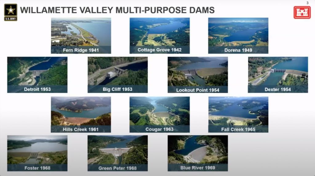
Emergency preparedness teams from three northwest neighborhoods welcomed a discussion on flooding. Introducing Jacque Wurster at the River Road Community meeting on Nov. 14, co-chair Clare Strawn.
[00:00:11] Clare Strawn (RRCO co-chair): So, Jacque, who started up the emergency prep team and has been a very good leader in making this happen, is going to take it over from here. Jacque, it’s over to you.
[00:00:22] Jacque Wurster (Ready NW): Thanks, Clare. We formed this committee back in 2020…to increase community engagement, to identify hazards, risks and threats within our neighborhood, and then also to develop some response plans whenever we do figure out what those risks and threats are.
[00:00:39] And one of the risks and threats that we’ve identified is the fact that we all live so close to the Willamette River here in the very-low-elevation part of town. We have contacted the U.S. Army Corps of Engineers and invited them to come and talk to us tonight about dam safety and flood inundation mapping.
[00:00:59] So with that, I’m going to introduce Dustin Bengtson.
[00:01:04] Dustin Bengtson (U.S. Army Corps of Engineers): Thank you very much. I am the deputy operations project manager for the Willamette Valley Project. That’s the 13 dams here in the Willamette Valley system. I’ve been here since 1993, so I’ve seen a few extreme weather events…
[00:01:19] I, like you, live below one of those nine dams in Lane County. I raise my kids below one of those nine dams in Lane County, and I told Charlsey (Cartwright) earlier, I don’t go to sleep at night worried about their safety…
[00:01:29] Just before the pandemic, right, 2019, we were commemorating 50 years of the Willamette Valley Project in operation, and we had a number of events planned to help raise or re-raise awareness. We know a lot of people have moved into the Willamette Valley and it’s not surprising at times to find folks that don’t know that they live below dams.
[00:01:47] And then in 2019, obviously, we had that April storm event, the big disruption, but we also had a very large snow event and a fairly large flood event in the Willamette Valley, reminding people what is the primary purpose and why were these dams constructed: Flood risk management is that prime driver.
[00:02:04] Since the dams were constructed, probably (prevented) in excess of $25 billion of flood damages. And of course, on an annual basis, those numbers increase rapidly as there’s more development in the valley and people are moving in.
[00:02:18] In that April storm event, in a seven-day span, the operation of our dams to reduce flows on the downstream main stem of the Willamette prevented about $2 billion in flood damages, right? That’s just in a seven-day span.
[00:02:33] In addition to the dams themselves, you have hundreds of miles of revetments— structures that were built to stabilize the banks of the Willamette River, as well as a number of hatcheries that were constructed over that same span of time that we operate and maintain as well.
[00:02:51] Jacque Wurster (Ready NW): We also have Matt Chase here tonight, who is the dam safety program manager of the Dam and Levee Safety Section.
[00:02:58] Matt Chase (U.S. Army Corps of Engineers): So these are the three levels of risk assessment: So again, the periodic assessment. The periodic assessment happens every 10 years. It happens to all dams. Then the next level of assessment, are what we call issue evaluation studies. So these are prioritized on a national basis. But if we find that the risks are not tolerable, we’ll move on to the next level, which is what we call a dam safety modification study. And we have done risk assessments on all of our dams at this point now, at least once.
[00:03:25] John Q: After offering a quick overview of the National Inventory of Dams, Matt Chase.
[00:03:29] Matt Chase (USACE): That is kind of a flying tour of the National Inventory of Dams website. There’s a lot of good information on this. You know, having this publicly available is going to prompt questions from people in the public as to how to operate it, what it all means and we’re here to help facilitate that discussion.
[00:03:45] We’re happy to have meetings and talk about it. We want folks to use this tool. We want them to be aware of the risks living downstream of a dam, what those pose. We want them to be aware of that. And also it’s to encourage a dialogue between the public and also their local emergency management agencies, how you would plan for an event like this.
[00:04:04] Clare Strawn (RRCO co-chair): Thank you for such a great overview. I’m curious if you could speak to anticipating the effects of climate change, particularly drought and the impact of that on electricity and/or all different impacts that might have.
[00:04:20] Dustin Bengtson (U.S. Army Corps of Engineers): That’s a big question, Clare. I don’t know that there’s a great predictive model out there that says what drought will look like for us.
[00:04:28] Things that I have read seem to indicate more extreme events. We’ve seen a couple of those type events play out in late spring in the last couple of years. In general, the more water we can store in the spring, the greater the range of opportunities we have during conservation season for downstream flow augmentation, for water supply, for recreation, etc.
[00:04:52] And, really, what we store in the system is a function of late spring rains, right? What we get in that April, May, and June timeframe really make the difference between a dry year and an abundant year.
[00:05:05] Julie Hulme: Are any of the Lane County dams scheduled or being reviewed for removal to help with salmon spawning and salmon runs to restore historic runs?
[00:05:17] Dustin Bengtson: I appreciate the question, Julie. Later this month I think around (Nov.) 30 the Corps will be releasing the draft set of recommendations for the update of our programmatic environmental impact statement. Dam removal is not one of the alternatives that is being considered. You know, removal would be a very different process, but I would really strongly encourage folks to pay attention and be engaged.
[00:05:40] There will be some sessions in early December that provide an overview of where we are in that new EIS and that’s a great time to become informed on what some of those changes might look like and what those tradeoffs are in terms of benefits.
[00:05:53] Julie Hulme: And is there any work being done as in the Netherlands it is currently being done, to relocate people out of the floodplain and inundation sites?
[00:06:03] Dustin Bengtson: I don’t have an answer to that one. That would not be something that we were specifically involved with as far as relocating folks out of the floodway.
[00:06:11] Jan Spencer (River Road): Have there been any ‘Pineapple Express’ events in recent years when there’s a low snowfall and then a big warm rain event, where the Corps of Engineers kind of were saying, ‘This looks serious’ ? Any types of worries that there could be an overflow just because of upstream flooding?
[00:06:36] Dustin Bengtson: Yes, we’ve had some really interesting recent events. In 2019, on top of that historic snowfall, in April of that year, we had a very unusual late rain event that came in and parked itself in the southern end of the Willamette Valley.
[00:06:50] And you saw that prediction for rainfall in like the Row River basin near Dorena and a few other places go from three inches to six inches to, you know, more than that in terms of actual, So you have rain on snow in low elevations. That’s typically what has meant historic flooding potential in the Willamette Valley.
[00:07:08] I’ve been here since ‘93. That’s the first time that I had seen all of our reservoirs at, or around 100%—just right at the top of our flood storage capacity, and we had some pretty unusual releases. To my knowledge, we didn’t have any impacts on structures, so we were right there on that very thin margin in that period from say, April to June—
[00:07:30] Remember this last summer, we had such a wet May and June, which really helped us in some areas provide conservation storage. But it’s not typical for us to see really heavy rainfall in those late events. So as we’re gradually refilling the pool, we try to get those pools as full as we can by Memorial Day each year, in mid-May.
[00:07:50] We’re also at a very risky time, right? So we’re higher, we’ve got less flood storage. So any of that late season rain that comes in can be a blessing, can also be a real challenge for us.
[00:08:00] Charlsey Cartwright (Ready NW): The two risks I saw referred to most often in the NID (National Inventory of Dams) for the potential of damaging the dams were if there was an unusually wet season and the ground gave way, and a very strong earthquake.
[00:08:18] In the River Road neighborhood, we are kind of landlocked in a way. If we had a very severe earthquake, the potential exists that the bridges and overpasses around us could fall. And we worry a lot about evacuation potential and so on. So part of what is intriguing about a dam breach is that we would have a period of time between the breach and when the inundation would be at its maximum height. Do you have anything to say about how much time, a ballpark as to when that breach occurs and that water reaching us, in huge amounts.
[00:09:04] Matt Chase (USACE): Thank you for the question. I have to kind of go back and repeat, you know, there’s a lot of assumptions that go into these maps and they are not really specific to the type of failure. But I took a look at, for Lookout Point, so for the normal high pool—which is kind of the one I like to use as an example because the pool is that elevation for part of the summer at least—so it would be roughly be, and I’m going to say very roughly, between six and eight hours to arrive to downtown Eugene proper.
[00:09:35] Ed Farren (Ready NW): How likely is it if an upstream dam fails that there’s a domino effect and it causes a downstream dam to fail.
[00:09:45] Matt Chase (USACE): That Hills Creek inundation assumes that the two subsequent dams, that being Lookout Point and Dexter, those two would also overtop and fail. So that inundation downstream assumes the failure of those two subsequent dams. I can’t speak to that’s how they’re all modeled, but I know that in that particular scenario, that was how it was modeled.
[00:10:06] Jon Belcher (RRCO co-chair): We all know that someday in the future we’re going to have a significant earthquake in our neighborhood. And my question therefore is: Has there been any modeling done about how well the dams would survive such an earthquake, magnitude 8 or 9 on the coast?
[00:10:22] Jacque Wurster (Ready NW): Natalie Ehrlich, geotechnical engineer of the Dam and Levy Safety Section.
[00:10:30] Natalie Ehrlich (U.S Army Corps of Engineers): Thanks for bringing that up. The short answer is, in our most likely Cascadia scenario we expect the dams to perform well. We would expect to see some damage. We could see cracking in the concrete structures. We could see some cracking in those earthen dams. We don’t expect a catastrophic failure.
[00:10:45] Jon Belcher (RRCO): What might happen if there was a landslide during a full pool event that might cause water to slosh over the dam and compromise the dam, say, Hills Creek at high water level.
[00:10:56] Natalie Ehrlich (USACE): You know, we sit around in a room for two weeks and brainstorm everything that could possibly go wrong for these earthquake scenarios and flood scenarios. And a landslide depositing into the reservoirs is something that comes up and that we consider for all of the projects in these risk assessments.
[00:11:12] And what we found is that just based on the amount of material that could go in there, we wouldn’t expect a catastrophic failure or a breach to occur from that. We could have some sloshing over the dam, but ultimately what we find is that it wouldn’t result in a failure.
[00:11:30] Matt Chase (USACE): You might remember back in 2011 there was a magnitude 9.0 subduction zone earthquake in Japan—the Tōhoku earthquake and you might recall that resulted in a large tsunami, a lot of loss. That earthquake affected like around 400 dams or something like that. And of all those dams, only one failed out of that event, which is kind of an older agricultural dam, I believe. There is a data point there that is a similar event to what, we might be able to expect here.
[00:11:58] Charlsey Cartwright (Ready NW): Let’s say that a very unlikely breach occurs in the middle of the night, 2:30, 4:00.
[00:12:09] Dustin Bengtson (USACE): We have a lot of instrumentation in place that would tell us if there’s a change in pool elevations or something that was happening downstream. In an earthquake scenario, it immediately triggers. So even that small earthquake that we had recently triggered inspection requirements for us at all of the dams within the Willamette Valley, and we were able to get folks out on the structures within hours to do inspections on all of those facilities.
[00:12:33] So it’s a little bit of a difficult question to answer, but our notification systems with Lane County have been tested in a number of events—flood events, recently fire events. We have that communication path really well dialed-in with the county.
[00:12:49] Jolene Siemsen (River Road): There is a strong likelihood of a megastorm event in California based on climate change models. And I read that article and I thought, well, I think there’s a likelihood in the Pacific Northwest based on our recent experiences.
[00:13:06] I understand your instrumentation would tell you if the flow was going over the top. Is there any system in place for letting us know when we’re like at 75%?
[00:13:18] Dustin Bengtson (USACE): One area that I would steer everyone to is the Willamette teacup diagram. And what the Willamette teacup diagram will show you is where we are in pool elevation at any given point, right, how much storage we have left. It will show you inflow and outflow.
[00:13:34] So it’s pretty unusual for us to be like we were this year at full pool all at the same time for an extended period, ’cause we had some extended rains into June. More likely, you’ll see us further down in our conservation storage. But it is a great tool to kind of understand the overall risk and what we’re releasing out of the dams.
[00:13:51] The other site that I really think folks will get a lot out of is the Northwest River Forecast Center site. And you can see not just the local but the regional kind of picture of what’s happening. And those are really good tools to be informed on what’s going on around you.
[00:14:08] Jon Belcher (RRCO co-chair): A long time ago, I had the opportunity to tour Lookout Point Dam, and in the operations room there was a huge graph on the wall that was ‘The Curve.’ Is that curve still sacrosanct and has it been modified to account for current changes in our climate?
[00:14:27] Dustin Bengtson (USACE): Yeah, thanks for the question. So, the curve that he’s referring to: Each one of our dams has an authorization, so, how we operate throughout the year to provide the greatest amount of conservation-season storage benefits, and diminish flood risks to the greatest extent possible. Those curves have not been modified and you are correct. You will see us in most cases operating below those curves.
[00:14:51] But there is always some tension around that, right? There’s an interest at times from folks to say, ‘Well, we want to make sure that that pool is full every summer for recreation purposes.’ And the answer to that is, ‘No, because if we fill sooner, we increase the risk to flooding downstream.’
[00:15:05] So we’re going to continue to operate along this authorization line. And to this point, none of those curves have been modified based on climate. So we are still operating under those same rule curves or those authorization curves that we had when the project was developed. But we have a lot more tools now in terms of prediction for flows and for forecasts than we perhaps did in the past.
[00:15:31] Kate Perle (Santa Clara): So, In Santa Clara, I know there are areas where the revetment in recent years has been completely washed away, and that has precipitated loss of acres of farmland here, and particularly across from the confluence of the McKenzie and Willamette in our neighborhood. There’s a neighbor who’s had that happen and she doesn’t have any recourse to replace revetment or reclaim property. How often is revetment along the floodway inspected, and then what is the process for failure of revetment, and then how is that accounted for in the modeling?
[00:16:06] Dustin Bengtson (USACE): That’s a great point. The revetments that were put in along the Willamette River were put in really for the purposes of stabilizing the banks. Most, if not all of them, were not designed to be true levies to provide flood control. A number of those revetments, after they were constructed, were turned over to local entities to operate and maintain. And that’s what makes it so complicated. But as you mentioned, a lot of those structures are fairly old and the river is dynamic and some of those structures have started to peel away from the banks.
[00:16:34] And so I would suggest a future conversation to help explain the levy program: What we do there in terms of inspection and what local entities do in terms of operation and maintenance of some of those structures.
[00:16:49] Jacque Wurster (Ready NW): Our next monthly emergency preparedness team meeting is going to be on Dec. 6, and we’re going to dedicate that whole meeting to unpacking things that we learned here tonight, talking about follow-ups and next steps, looking for volunteers to take things to the next level. So everybody feel free to join us if you’re available.
[00:17:05] And if you’d like more information about what we’re doing or you have specific questions, that email is ReadyNWEugene@gmail.com.
[00:17:14] John Q: Ready Northwest looks at potential flooding threats in their neighborhoods.